
HydroClimExHydroclimate Extremes LabWestern University

Research

Research themes

Four connected programs, from storm and climate processes to the values engineers design for. Each program links to the projects, people and papers behind it.

Precipitable water as an atmospheric river reaches the Pacific coast, January 2015. Animation: NOAA

Program 1

Compound flood processes

When rain, river flow, storm surge and waves peak together, the flood is worse than any one of them suggests. We study compound flooding on Canada's Pacific and Atlantic coasts, in the Great Lakes and in inland basins, separate it by storm type, and project how warming changes it. Work on Arctic coasts is in development with federal partners.

  • Copulas and nonstationary joint return levels
  • Storm typing: extratropical cyclones, atmospheric rivers, post-tropical storms
  • Physical coastal processes: waves, setup, runup, overtopping and erosion (a developing research line, started 2026)

People: Jiajin Feng, Behnaz Hadi, Yasaman Taleghani, Mehrdad Jafarzadeh, Tianze Pang
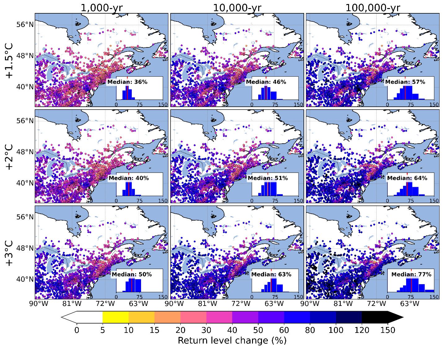
Maps of projected change in extreme flood return levels across eastern Canada at 1.5, 2 and 3 degrees of warming
Projected change in 1,000, 10,000 and 100,000-year flood levels across eastern Canada at 1.5, 2 and 3 °C of warming. PhD research, M.R. Islam. Very long return periods are extrapolations with wide uncertainty and are shown for research comparison, not for design.

Program 2

Hydroclimatic swings and changing extremes

How extremes are changing and why. A core line of work is hydroclimatic swings, also called weather whiplash: rapid transitions from drought to deluge, or wet to dry, that strain reservoirs, dams and drainage. Using large climate model ensembles, we separate human influence from natural variability and project how swings, successive and lagged flood and drought events, rain on snow and short-duration design rainfall change with warming.

  • Dry to wet and wet to dry swings across North America, the Great Lakes and East Asia
  • Successive and lagged compound floods and droughts
  • Climate-adjusted IDF curves and probable maximum precipitation
  • Detection and attribution with large ensembles

People: Jack Warden, Issam Mohamed, Yasaman Masaeli; alumni Wooyoung Na, Melika RahimiMovaghar, Reza Rezvani, Andrew Grgas-Svirac

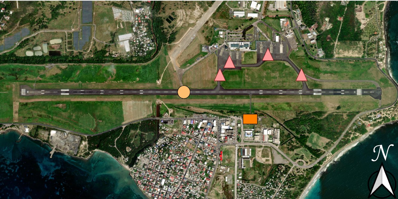
Satellite view of Hewanorra International Airport, Saint Lucia, marking the runway, taxiways, apron and fire and rescue building affected by flooding
Flood-affected facilities at Hewanorra International Airport, Saint Lucia, after Tropical Storm Matthew (2016): runway (circle), taxiway and apron (triangles) and fire and rescue building (square). PhD research, S. Bakhtiari

Program 3

Flood modelling, remote sensing and risk

We translate flood simulations into estimates of exposure, infrastructure disruption and risk. We build hydrologic and hydrodynamic model chains, train fast emulators on them, map floods from satellite radar, and use deep learning on street-level imagery and LiDAR to describe the buildings in harm's way.

  • WRF-Hydro, Raven, SFINCS, LISFLOOD-FP, TELEMAC-2D and PCSWMM
  • Machine learning emulators and regional flood frequency
  • Urban flood mapping from Sentinel-1 and RADARSAT Constellation Mission radar with deep learning
  • Building exposure from Google Street View, LiDAR and orthophotos: first floor heights and land use
  • Satellite and radar precipitation (IMERG, MRMS) evaluated and bias-adjusted across Canada

People: Mehrdad Jafarzadeh, Omar Abusanina, Jiajin Feng; alumni Nafiseh Ghasemian Sorboni, Md. Robiul Islam, Saber Moazami, Mohammad Fereshtehpour

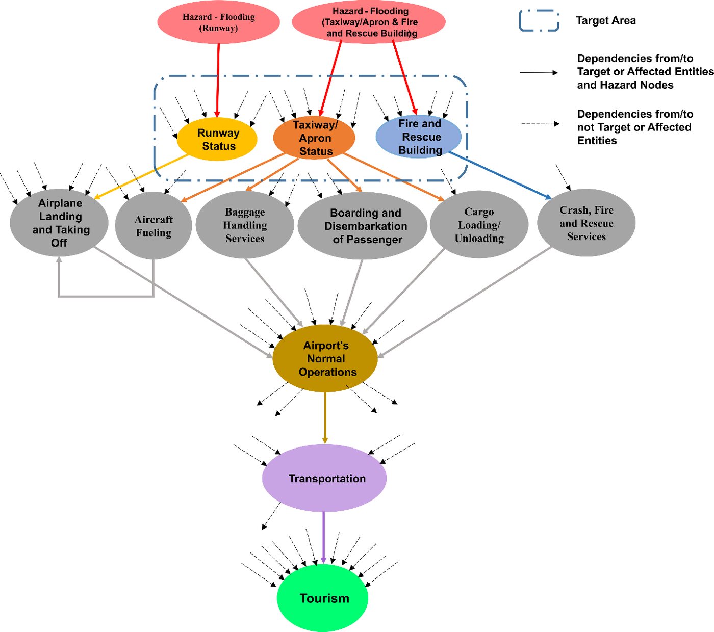
Dependency network showing how flooding of airport facilities propagates to airport services, operations, transportation and tourism
How flooding at Hewanorra International Airport, Saint Lucia, spreads through airport services to operations, transportation and tourism, from a dynamic Bayesian network. Bakhtiari et al. (2025). See the case study

Program 4

Infrastructure and multihazard resilience

Floods, hail and wind knock out power, water and transport, and the failures cascade. We trace those chains with network risk methods and dynamic Bayesian networks, first in Saint Lucia, and study the storms behind them, including hail in Alberta through the Northern Hail Project. Much of this work runs through Western's Centre for Multihazard Risk and Resilience, which Reza Najafi cofounded and co-directs.

  • Cascading failures and recovery in interconnected infrastructure
  • Multi-state and fuzzy Bayesian networks for expert-informed risk
  • Compound hail, wind and rain extremes
  • Wind-driven rain and hail on buildings

People: Issam Mohamed, Yasaman Masaeli; alumni Soheil Bakhtiari and Ying (Katrina) Zhang; with CMRR colleagues

How we work

From climate data to flood risk assessment

Climate forcing

Reanalysis, regional and global projections, radar and gauges

ERA5CORDEXd4PDF

Process models

Hydrology, lake and coastal hydrodynamics, urban drainage

WRF-HydroRavenSFINCSTELEMAC-2D

Statistics and ML

Nonstationary extremes, copulas, metastatistical methods, emulators

GEV/GPDMEVemulators

Hazard and risk

Joint return levels, inundation maps, exposure, cascading failures

LISFLOOD-FPPCSWMMBayesian networks

Guidance and tools

National assessments, standards, federal web tools, municipal design values

IDFCSAweb tools

High-resolution climate and hydrodynamic modelling runs on a national computing allocation from the Digital Research Alliance of Canada.